

Wildfire Mitigation
PROACTIVELY MITIGATE WILDFIRE RISK
Target the work that matters most for safety and reliability with Arcos Clearion’s data-driven vegetation insights. Rank high-risk spans and assets to prioritize vegetation management efforts and build out sound strategy.

Trusted by Fortune 150 & Utilities

DATA-DRIVEN INSIGHTS HELP UTILITIES TARGET HIGH-RISK SPANS AND PREVENT WILDFIRES

Execute Wildfire Prevention Efforts More Quickly and Safely
Risk-Based Planning
Targeted Field Execution
Compliance & Transparency
Maximize Budgets on High-Risk Spans
Combine fire-risk layers (fuels, slope, wind, WUI), clearance data, asset criticality, and outage history to rank spans objectively.
- Concentrate effort and budget on the highest risk spans, driving measurable risk reduction
- Clearion executes spatial analysis and program optimization in a GIS-native model

Put the Right Crew on the Right Span
The right work gets done right the first time with guided digital work packets incorporating maps, hazards, and required steps; crews capture photos, GPS, and signatures as they work on or offline.
- Fewer callbacks, less rework, faster mitigation per mile
- Standardize digital capture across internal and contractor teams

Document and Report on Wildfire Reduction Efforts
Documentation is attached to assets and work packets for streamlined reporting without manual stitching.
- Improve confidence in audits and stakeholder reporting, with location-based documentation
- Clearion seamlessly brings your data and digital into your ArcGIS system

From Activation to Closeout: How ARCOS Works
Risk-Based Program Strategy
Extend the value of drone and LIDAR imaging to directly guide proactive vegetation management.
Guided Execution Workflows
Digital packets with maps, hazards, and clear steps; capture photos, GPS, and e-signatures in real time.
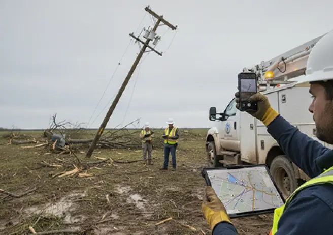
Rapid Hazard Response
Rules-driven mobilization assembles qualified vegetation crews in minutes for urgent mitigation or follow-up work.
.svg)
Detailed Documentation and Reporting
Location-based summaries with time, photos, and signatures exported per span, parcel, and corridor.
Customer Stories
Trusted by Leading Utilities
Across North America
“The key to being successful is combining multiple inputs into a single view - from remote sensing; aerial, visual, and ground patrols; and cycle based preventative maintenance like bare ground pool treatments. This is how you can have a unified risk profile for vegetation and asset health across your grid.”
Orchestrate Proactive Wildfire Mitigation


PREHEADER
DISCOVER HOW ARCOS CONNECTS
PRODUCTS
INDUSTRIES


SCHEDULING & AVAILABILITY
Real-time system of record for shifts, rosters, and crew status.
CREW CALLOUTS
Real-time system of record for shifts, rosters, and crew status.
MOBILE ACCESS
Real-time system of record for shifts, rosters, and crew status.
COMPLIANCE & REPORTING
Real-time system of record for shifts, rosters, and crew status.
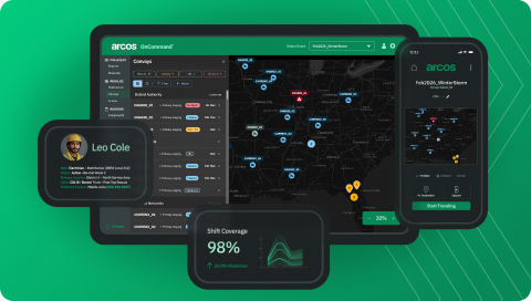
OnCommand Suite
A Single Control Center for Utility Operations
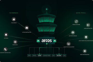
Field Crews
Manage your utility workforce with automated callout, scheduling, and real-time field coordination tools.
Native Contractors
Coordinate internal contractor resources with mobile access for assignments, time tracking, and compliance.
3rd-Party Contractors
Standardize external contractor work execution with streamlined mobile tools and expense tracking.
Mutual Aid
Request and manage external utility resources seamlessly within your existing crew management system.
ICS Roles
Assign and track Incident Command System roles for coordinated emergency response and compliance.
Assess & Restore
Document damage and coordinate restoration efforts in real time during outages and storm events.
Line Construction
Execute network expansion and capital projects with digital workflows and GIS-enabled mobile tools.
Customer Service
Enable two-way communication for outage reporting, service requests, and billing notifications.
Asset Inspection & Maintenance
Maintain compliant digital records of asset condition with automated notifications and GIS capture.
Vegetation Management
Plan, execute, and report on vegetation work with integrated GIS-native lifecycle management.
Grid Modernization
Support system upgrades and technology deployments with digital workflows and project tracking.

